 One of our recent “science” lessons involved mapping and compass directions. Camille spent roughly a week on the topic and did a wonderful job working in the children's recent learning about early American history: they could understand that the Europeans came west across the Atlantic, and they now have a sense of how western expansion proceeded across the United States.
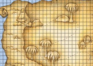
I got to cap the week with a little lesson of my own. I pulled an image of a pirate's treasure map off the Internet. It showed a desert isle with palm trees and boulders and had a weathered look about it.
Then I overlaid a grid pattern onto the map using the transparency layers built into Paint.Net (my free, image-editing tool of choice). I printed the map, drew a starting point on it, and worked out a series of steps to navigate from here to there on the paper. I put the steps into a “pirate” letter:
Dear Pirate,
A. Move two steps to the north.
B. Walk four steps to the west.
C. Swim three squares to the north.
etc.
Hugs and Kisses,
Long John Silver
Another copy of the map served as the answer key. On this copy, I drew a “treasure” on the correct end-spot. The children worked through the exercise, and when they came to the end, they punched holes in their maps. By holding their maps over my key, we could see whether or not they had successfully “found” the treasure by looking through the whole.
A few weeks later, Camille was teaching the children measurement, and I resurrected the pirate maps. This time I gave the instructions in inches: “Move two inches to the north,” etc. Again, the game was a hit.
I'm toying with the idea of creating an online version of the exercise, but I'm not sure kids would enjoy it as much. Our children really savored physically marking up their maps and punching those holes once they had pinpointed the treasures.
No comments:
Post a Comment